Log in
All resources
Create a design
99 Free Artworks of 1580 Maps
lucas janszoon waghenaer
bibliothèque nationale de france
maps in the rijksmuseum amsterdam
prints by joannes van doetechum (i) in the rijksmuseum amsterdam
maps of bergen (norway) by braun & hogenberg
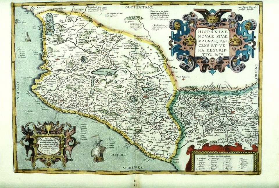
1580s maps of spain
history prints in the rijksmuseum amsterdam
world map
antique
atlas
illustrations of cosmographia (münster)
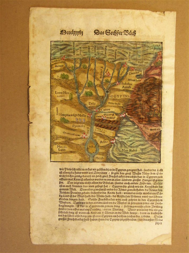
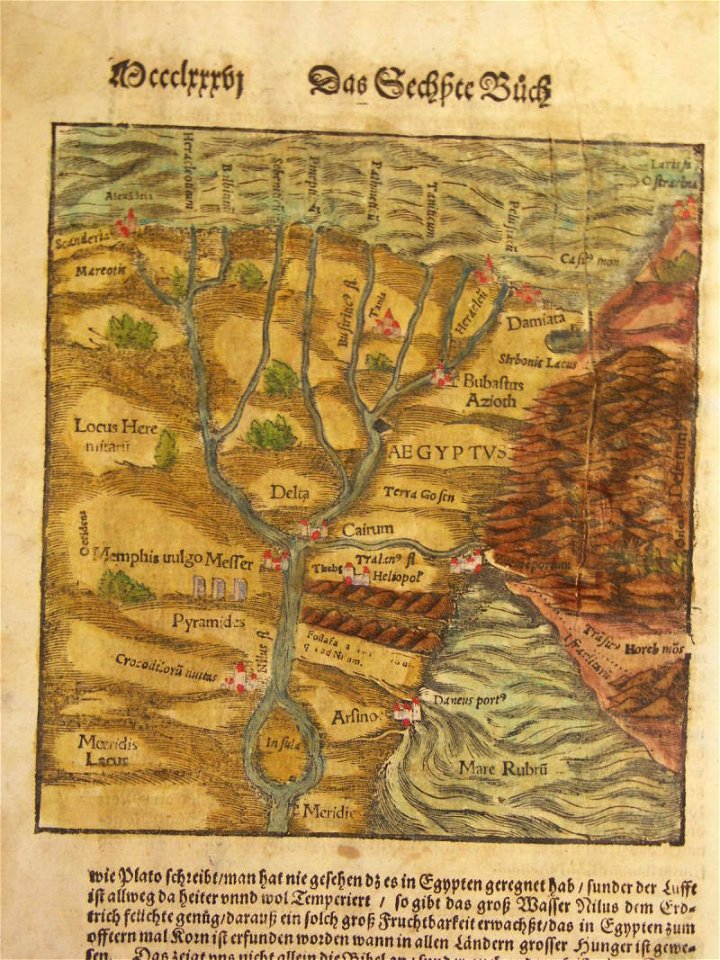
1580s maps of egypt
illustrations of cosmographia (münster)
1580s maps of egypt
history of perugia
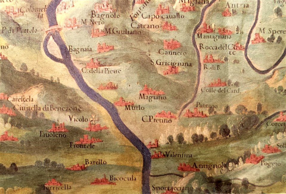
old maps of umbria
maps by sebastian münster
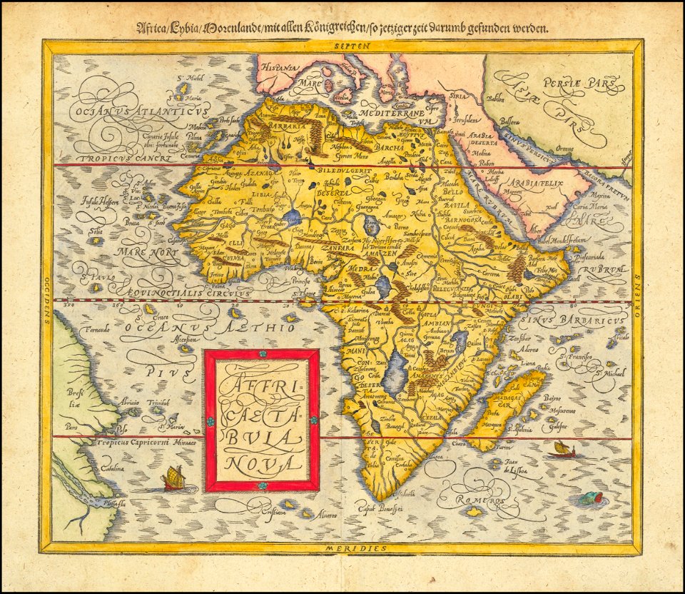
1580s maps of africa
water transport in vyborg
lucas janszoon waghenaer
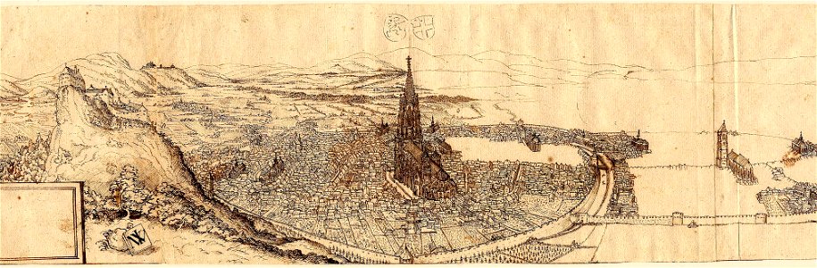
old maps of freiburg im breisgau
ink drawing
1590s maps of the world
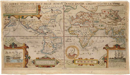
francis drake
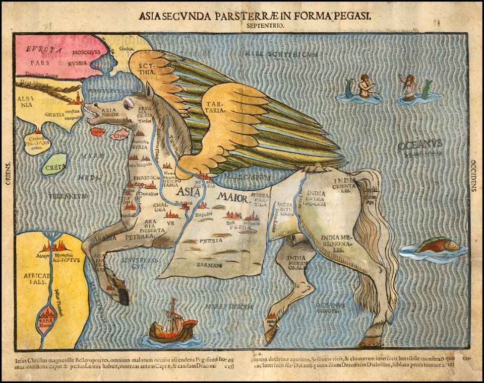
asia secunda pars terrae in forma pegasir
1580s maps of asia
vintage
maps
vintage
maps
world
maps
world map
maps
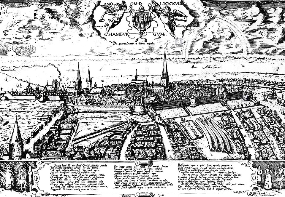
historic views of hamburg
staatsarchiv hamburg
theatrum orbis terrarum (london 1606)
files from the bodleian libraries
old constellation maps
maps by samuel dunn
old maps of the province of bergamo
1580 maps
al-andalus
portugal
lucas janszoon waghenaer
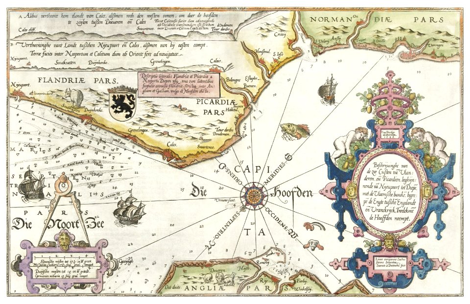
bretagne in the 1580s
italia antiqua (galleria delle carte geografiche)
old maps of italy
maps of delft by braun & hogenberg
bibliotheek, tu delft
maps of edinburgh by braun & hogenberg
16th-century maps of scotland
maps of bergen (norway) by braun & hogenberg
1580s engravings
1580s maps of the netherlands
1580s maps of belgium
paintings of battle of lepanto
museo storico navale (venice)
dresden in the 1580s
leipzig in the 1580s
copper engravings in the universitätsbibliothek salzburg
wolf-dietrich-klebeband städtebilder
maps of delft by braun & hogenberg
cartouche (cartography)
maps of vienna by braun & hogenberg
vienna in the 1580s
copper engravings in the universitätsbibliothek salzburg
wolf-dietrich-klebeband städtebilder
maps of wales by humphrey llwyd
theatrum orbis terrarum
maps of bergen (norway) by braun & hogenberg
hieronymus scholeus
historical images of håkonshallen
bergenhus festning in art
maps of speyer by braun & hogenberg
maps of worms by braun & hogenberg
maps of delft by braun & hogenberg
media from tu delft
maps of bergen (norway) by braun & hogenberg
hieronymus scholeus
maps of bergen (norway) by braun & hogenberg
churches in bergenhus
transpadana venetorum ditio (galleria delle carte geografiche)
old maps of the province of bergamo
royal coats of arms of norway
hieronymus scholeus
beschreibung der städt der welt - braun & hogenberg - btv1b52512111k
dresden in the 1580s
1570s maps of the ottoman empire
1576 maps of europe
liebfrauenkirche halberstadt
halberstadt cathedral
1580s maps of the world
1598 maps
1580s maps of the holy roman empire
copper engravings
maps of diu by braun & hogenberg
maps of diu by braun & hogenberg
maps of diu by braun & hogenberg
sicilia (galleria delle carte geografiche)
1580s maps of sicily
1580s maps of belgium
copper engravings
malta (galleria delle carte geografiche)
old maps of malta
1580s maps of the world
1589 maps
illustrated title pages from the netherlands
joan blaeu
lucas janszoon waghenaer
old maps of the arctic
maps of goa by braun & hogenberg
old maps of plymouth and devonport
16th-century maps of england
maps of goa by braun & hogenberg
maps of goa by braun & hogenberg
maps by pieter van der keere
maps by abraham ortelius
native american history of virginia
17th-century maps of virginia
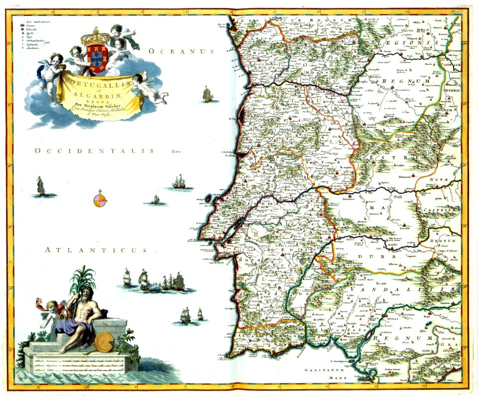
1580s maps of portugal
old maps of portugal
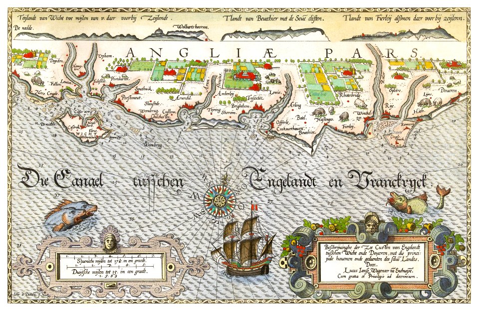
zee kaerte van bretaigne, inhoudende die zee custen, baijen, eijlanden, ende havenen, tusschen rouscou ende groije - met grooter neersticheyt gecorrigeert door lucas iansen waghenaer van enchuijsen 1580 - btv1b53156698p
bibliothèque nationale de france
zee kaerte van bretaigne, inhoudende die zee custen, baijen, eijlanden, ende havenen, tusschen rouscou ende groije - met grooter neersticheyt gecorrigeert door lucas iansen waghenaer van enchuijsen 1580 - btv1b53156698p
bibliothèque nationale de france
zee kaerte van bretaigne, inhoudende die zee custen, baijen, eijlanden, ende havenen, tusschen rouscou ende groije - met grooter neersticheyt gecorrigeert door lucas iansen waghenaer van enchuijsen 1580 - btv1b53156698p
bibliothèque nationale de france
old maps of toledo, spain
1580s maps of spain
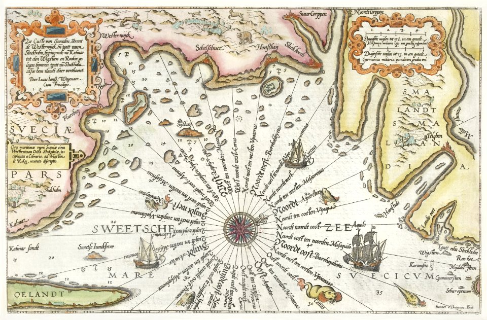
old maps of västra götaland county
old maps of göteborg
gerardi mercatoris atlantis novi. pars tetria (1638)
17th-century maps of lombardy
lucas janszoon waghenaer
1580s maps of spain
wolffgang hartmann
philipp clüver
maps and topographical views by joris hoefnagel
1580s maps of spain
1580s maps of the americas
hakluyt-martyr
maps of kraków by joris hoefnagel
joris hoefnagel
1580s maps of spain
1586 maps
16th-century maps of lisbon
1580s maps of portugal
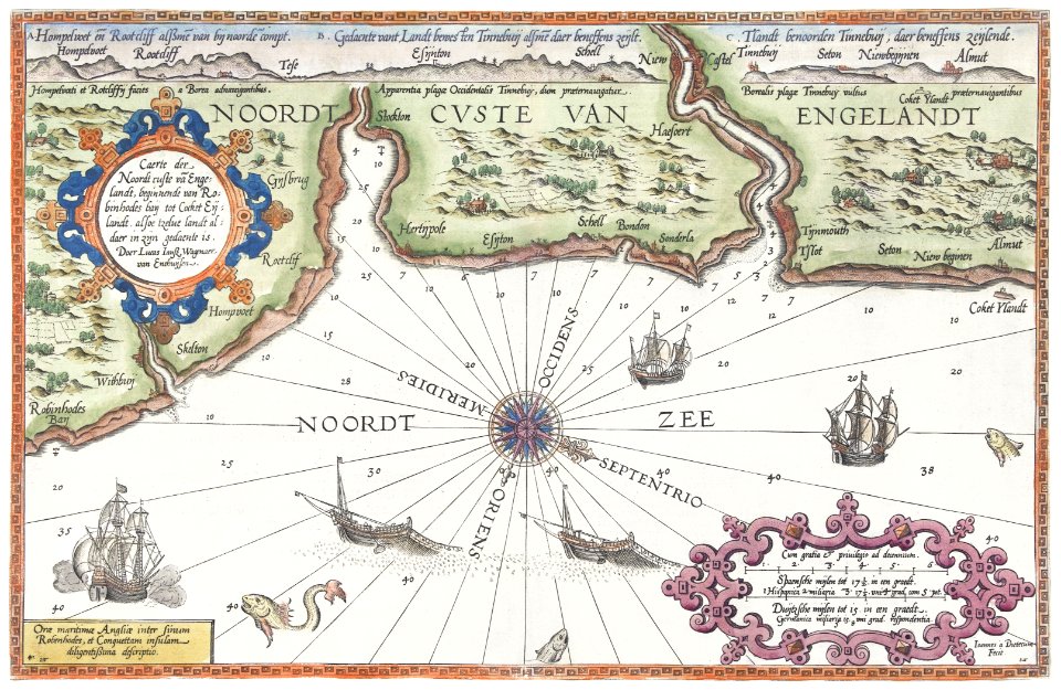
beschrijvinge vande uuterste omlopende custe van iudtlandt aen weder zijden op de belt ende noortzee, in zijn wesen ende gedaente tusschen aelburger diep ende rijncopen - lucas ioannes aurigari(us) autore... - btv1b53235832k
bibliothèque nationale de france
beschrijvinge vande uuterste omlopende custe van iudtlandt aen weder zijden op de belt ende noortzee, in zijn wesen ende gedaente tusschen aelburger diep ende rijncopen - lucas ioannes aurigari(us) autore... - btv1b53235832k
bibliothèque nationale de france
beschrijvinge vande uuterste omlopende custe van iudtlandt aen weder zijden op de belt ende noortzee, in zijn wesen ende gedaente tusschen aelburger diep ende rijncopen - lucas ioannes aurigari(us) autore... - btv1b53235832k
bibliothèque nationale de france
maps of chalon-sur-saône by braun & hogenberg
maps of mâcon by braun & hogenberg
maps of roanoke island
theodor de bry
die zee custen van biscaijen tusschen laredo ende sentillana soe hem dat selve landt all daer verthoont ennde opdoet - lucas ioannes aurigarius inventor ; ioannes à doetecum fecit - btv1b531945334
1580s maps of spain
history of copenhagen
1587 in denmark
1580s maps of the americas
frans hogenberg
john and sebastian cabot. a study (1886)
1580s maps of north america
maps in the rijksmuseum amsterdam
lucas janszoon waghenaer
a briefe and true report of the new found land of virginia
theodor de bry
maps in the rijksmuseum amsterdam
lucas janszoon waghenaer
maps in the rijksmuseum amsterdam
lucas janszoon waghenaer
maps in the rijksmuseum amsterdam
lucas janszoon waghenaer
maps in the rijksmuseum amsterdam
lucas janszoon waghenaer
maps by jodocus hondius
1590s maps of the world
maps in the rijksmuseum amsterdam
lucas janszoon waghenaer
cremona fedelissima citta et nobilissima colonia de romani (1585)
old maps of cremona
prints of cartouches in the rijksmuseum amsterdam
maps in the rijksmuseum amsterdam
nederlandse en buitenlandse gebeurtenissen
album met 345 prenten van hogenberg
cremona fedelissima citta et nobilissima colonia de romani (1585)
old maps of cremona
prints by claes jansz. visscher (ii) in the rijksmuseum amsterdam
maps in the rijksmuseum amsterdam
prints by claes jansz. visscher (ii) in the rijksmuseum amsterdam
maps in the rijksmuseum amsterdam
prints by simon frisius in the rijksmuseum amsterdam
etchings in the rijksmuseum amsterdam
serie 9, nederlandse en duitse gebeurtenissen, 1583-1587
album met 345 prenten van hogenberg
prints by claes jansz. visscher (ii) in the rijksmuseum amsterdam
siege of sluis 1604
prints by pieter hendricksz. schut in the rijksmuseum amsterdam
amsterdam in the 1580s
1 - 99 of 99
/ 1


![Carpetaniae partis descr. / [Georgius Hoefnaglius], Joris Hoefnagel, 1584](https://cdn.creazilla.com/illustrations/10000765930/carpetaniae-partis-descr-georgius-hoefnaglius-joris-hoefnagel-1584-sm.jpg)


![Matiscona, vulgo Mascon; ad Ararim flu. probe munitum Burgundiae oppidum M.D.LXXX; Cabillinum, Indigenis Chalon, ut agri uberrimi [...] felix Burgundiae opp. [...], 1635](https://cdn.creazilla.com/illustrations/10000494206/matiscona-vulgo-mascon-ad-ararim-flu-probe-munitum-burgundiae-oppidum-mdlxxx-cabillinum-indigenis-chalon-ut-agri-uberrimi-felix-burgundiae-opp-1635-sm.webp)


